Landsat Next Defined

Landsat Next Defined

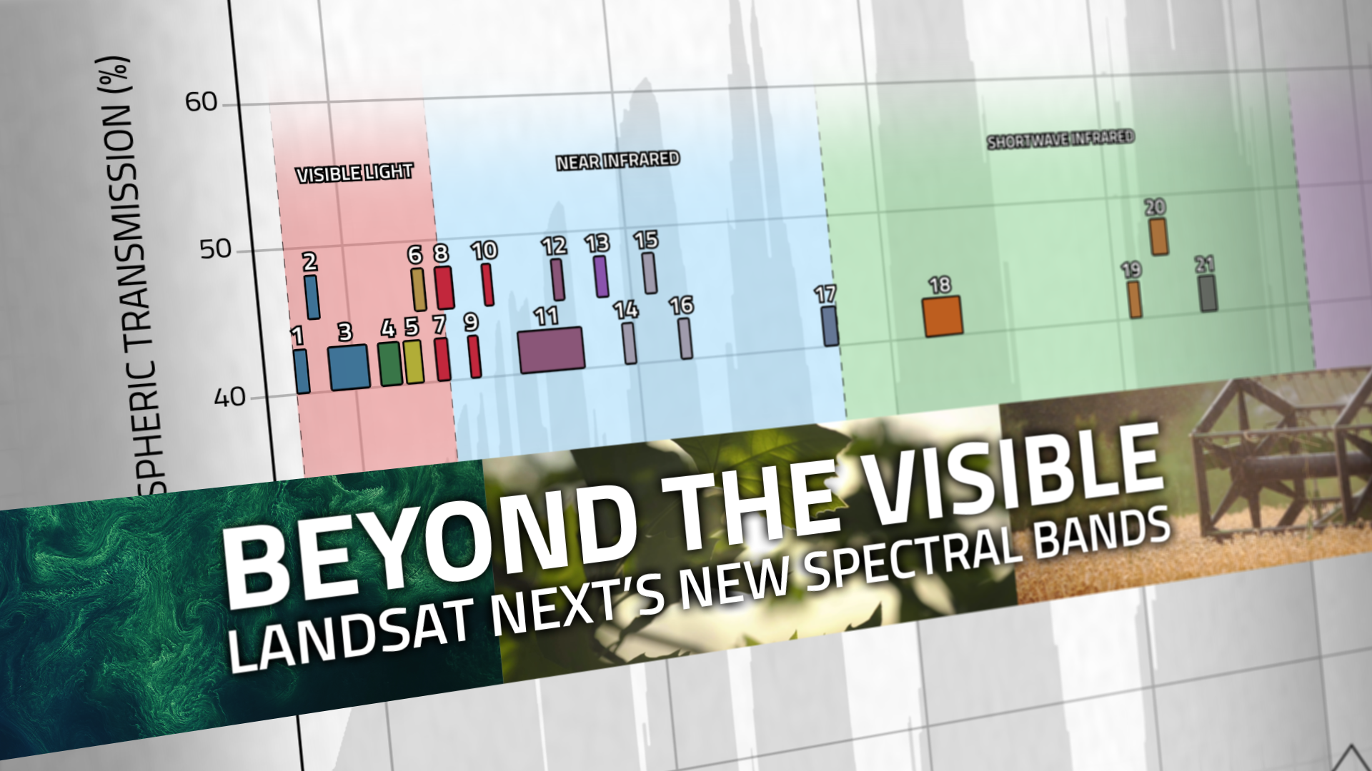
Landsat Next is on the horizon—the new mission will not only ensure continuity of the longest space-based record of Earth’s land surface, it will fundamentally transform the breadth and depth of actionable information freely available to end users. Take a look at the new capabilities that will define the next Landsat mission.

Read More »
Ross Walter (left) holds a letter O and Ally (right) holds the letter A. Both letters were found in Landsat imagery.

Finding Your Name in Landsat

More than 715,000 visitors have transcribed their names and messages into Landsat letters using the “Your Name in Landsat” tool since it was unveiled in August as part of Camp Landsat 2024.

Read More »
Landsat Next Defined

Landsat Next Defined

Landsat Next is on the horizon—the new mission will not only ensure continuity of the longest space-based record of Earth’s land surface, it will fundamentally transform the breadth and depth of actionable information freely available to end users. Take a look at the new capabilities that will define the next Landsat mission.

Read More »
Ross Walter (left) holds a letter O and Ally (right) holds the letter A. Both letters were found in Landsat imagery.

Finding Your Name in Landsat

More than 715,000 visitors have transcribed their names and messages into Landsat letters using the “Your Name in Landsat” tool since it was unveiled in August as part of Camp Landsat 2024.

Read More »

“Many people have no idea how Earth imagery has improved their daily lives as it has become integrated into modern technologies. Like GPS and weather data, information from Landsat is woven into the fabric of our economy and society.”


“I am a big fan of Landsat 8 satellite images as a resource when making maps.”


“The growth of open satellite-image archives such as Landsat is leading to more sophisticated data products.”


“The success of a mission, and the societal benefits it creates, relies on many factors, including design, manufacture, launch, and operation of the sensor. However, it also includes data acquisition, accessibility, availability, and continuity, all of which are embodied by the Landsat program.”


“With applied conservation programs, we’re using that [Landsat] imagery to say here are the areas that we can prioritize for conservation management, and here are areas that maybe we can let go. It’s a very powerful tool for getting conservation to happen.”


“Without Landsat’s long record, studies like ours would be impossible to undertake, because we don’t have a time machine to go back to the 1970s and 1980s and see how Turkey’s glaciers were doing then. Using Landsat and commercial satellite data together, we can map glaciers with high accuracy. It’s a powerful combination for studying the Earth from space.”


“This portal harnesses more than 37,000 images from Landsat archives, dating back to the early 1970s, to track changes in outlet glaciers over time.”


“There is no other asset in the sky that can show us what Landsat does in terms of the effect of this eruption and also the effect of recovery following the eruption.”


“During the decade following 1969, a singular development catapulted computer mapping: the launch of Landsat by NASA and the U.S. Department of the Interior in July 1972.”


“LANDFIRE is the only complete, nationally consistent collection of spatial resource datasets with an ecological foundation.”


“The Landsat science community is giddy at the results they’re seeing from the latest Landsat instrument. It’s that much better than the last one.”


“Satellite imagery can be used retrospectively, meaning that the data collected by satellites today will probably help solve issues we are not currently even aware of—an advantage which is invaluable.”


“Landsat is the longest civil satellite data collection we have. The USGS opening the archive has created opportunities for instructors like us to integrate students.”


“The Landsat data record is absolutely invaluable—wetland managers can start to understand if changes they are seeing take place over months, years or decades.”


“This portal harnesses more than 37,000 images from Landsat archives, dating back to the early 1970s, to track changes in outlet glaciers over time.”


“Landsat satellite data are the most important source we have about how much deforestation happens each year across the Amazon.”


“The Landsat mission has been monitoring Earth from orbit for more than 40 years. It is by far the longest continuous record of the surface of the planet, and certainly one of the most valuable data sets in existence.”


“Continental scale applications of medium and high-resolution earth observation data are becoming increasingly important and feasible, driven largely by free and open access to the Landsat archive…the Landsat archive offers a temporal dimension for decades long retrospective analysis and ongoing monitoring capabilities.”


“There is no better source of information [than Landsat] to document the changes happening to our planet’s landscapes­—and we need this continuous record to help our communities become more resilient to the dramatic effects we are seeing.”


“I am a big fan of Landsat 8 satellite images as a resource when making maps.”


“By using Landsat 8 imagery, and classification tree analysis, which is an advanced artificial intelligence routine, we have been able to construct a reliable classification system to identify cheatgrass infestations that is accurate. This has implications for fire susceptibility. Cheatgrass is driving wildfire on rangelands and we need to identify areas that have heightened susceptibility to wildfire.”


“Global Forest Watch’s ability to take advantage of Landsat imagery to produce a global forest monitoring platform highlights why remote sensing has become such a revolutionary technology. The imagery has achieved a state-of-the-art quality—NASA’s Landsat data is delivered in 30x30meter squares and has been for the past 40 years. Beyond this, it has been made radically accessible. Since 2008, anyone has been able to view and download the data from the United States Geological Survey (USGS) websi…


“When we showed historical Landsat and more recent high resolution images to communities and shared our analysis, people realized what they’d lost over time and wanted to engage in conversations about how to bring the forests back.”


Landsat 9 bw
Landsat 9 bw
Landsat 9 bw

The NASA/USGS Landsat Program provides the longest continuous space-based record of Earth’s land in existence. Landsat data give us information essential for making informed decisions about Earth’s resources and environment.